bamabikeguy
Active Member
...will probably be easier and take less time than figuring out how the MAPS programs work nowadays.
Get this, I had to cut up an old 1950's (pre-interstate highways) encyclopedia/atlas, do a bunch of scanning and cropping, to get a decent image to post !!
Maps are irrelevant once I get on the road, due to my tendency to follow the wind and end up 50 miles from that day's target. When I punched up this first part of the journey, Alabama to North Carolina, it was 457 miles by car, but 422 "walking". (Part of the first day will be retracing a route from my September '06 Mt. Cheaha trip, where I "lost" 140 pictures switching to Google's Picasa program, right before joining the forum.)
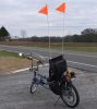
Since putting on the engine in December, I've done at least 500 miles of breaking in-3 oil changes, things are purring back behind the seat.
Some of the towns I'll pass in Georgia are Rome, Gainesville, up to Toccoa.
When I posted the plan at Daily Kos, a guy e-mailed me an invitation to dinner and potential campsite in Alto, which is about 204 miles from the house. At least the social part of the intratubz works better than the maps !!
Helen and Anna Ruby Falls are part of a German/Alpine replica town, which I thought might be my scenic time-outs. Helen is home of the Cabbage Patch Dolls, which holds zero interest for me, but there is a genuine German type brewery nearby, which holds a 6 pack of test packing.
I'll just zip through South Carolina, Seneca, Clemson, Westminster....but I want to be 30 miles north of Greenville and Spartanburg if I can.
Lincoln, Cherryville, Mooresville are on the route into North Carolina, where my Easter Grateful Greensboro Sunday Dead ticket awaits. Exit N.C. sometime Tuesday, either north through Galax/Roanoke or south toward Columbia.
There is reserved for me a ticket up in Virginia for a Charlottesville Dead show the next week, but I may just go south to Charleston, SC, where another friend has backstage contacts for some sort of jam-band festival going on down there the next weekend.
I've searched the threads to see if somebody has put the 4-stroke Robin Subaru on a cross country stress test. With this journey, & especially if I do the Charleston option, all the "hard miles" will be on Day 1-2, once I get in the flatlands it's a smooth cruise. I was thinking of doing a Virginia Bluegrass tour in October, that's just another reason to "go south" next month.
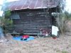
Estimated day of departure is Tues. April 7....Rucio the Pack Mule is still a work in progress !
Get this, I had to cut up an old 1950's (pre-interstate highways) encyclopedia/atlas, do a bunch of scanning and cropping, to get a decent image to post !!
Maps are irrelevant once I get on the road, due to my tendency to follow the wind and end up 50 miles from that day's target. When I punched up this first part of the journey, Alabama to North Carolina, it was 457 miles by car, but 422 "walking". (Part of the first day will be retracing a route from my September '06 Mt. Cheaha trip, where I "lost" 140 pictures switching to Google's Picasa program, right before joining the forum.)
Since putting on the engine in December, I've done at least 500 miles of breaking in-3 oil changes, things are purring back behind the seat.
Some of the towns I'll pass in Georgia are Rome, Gainesville, up to Toccoa.
When I posted the plan at Daily Kos, a guy e-mailed me an invitation to dinner and potential campsite in Alto, which is about 204 miles from the house. At least the social part of the intratubz works better than the maps !!
Hi Paul,
Gainesville to Toccoa takes you within a mile of my house. The road name changes from 985 to 365 around Gainesville, and you just stay on it and continue north from Gainesville through Clarkesville. A few miles north of Clarkesville the road splits, 441 heads north and 365 arcs off eastward at an easy-to-spot interchange. That takes you on to Toccoa.
Those are the 4-lane roads. The two-lanes that you want run a parallel route. Take "old" 23 out of Gainesville through Rabbit Town (ask a local) to Lula, then Alto within a mile of me, then Baldwin, then through Cornelia and on to Toccoa. It's the same "arc" but parallel to the 4-lanes and probably a much more comfortable speed for you on your bike!
If you want to stop in Clarkesville it's just a few miles off the route, on "old" 441 north of Cornelia and Demorest. From Clarkesville you could go on to Helen and Anna Ruby Falls, probably 25 miles or so.
BTW, if you can find Rabbit Town, stop in the Double D Burger on the right and get one of their cheeseburgers all the way. They put slaw on 'em too. And go ahead and program in my cell number if you want, 706--- ----
Helen and Anna Ruby Falls are part of a German/Alpine replica town, which I thought might be my scenic time-outs. Helen is home of the Cabbage Patch Dolls, which holds zero interest for me, but there is a genuine German type brewery nearby, which holds a 6 pack of test packing.
I'll just zip through South Carolina, Seneca, Clemson, Westminster....but I want to be 30 miles north of Greenville and Spartanburg if I can.
Lincoln, Cherryville, Mooresville are on the route into North Carolina, where my Easter Grateful Greensboro Sunday Dead ticket awaits. Exit N.C. sometime Tuesday, either north through Galax/Roanoke or south toward Columbia.
There is reserved for me a ticket up in Virginia for a Charlottesville Dead show the next week, but I may just go south to Charleston, SC, where another friend has backstage contacts for some sort of jam-band festival going on down there the next weekend.
I've searched the threads to see if somebody has put the 4-stroke Robin Subaru on a cross country stress test. With this journey, & especially if I do the Charleston option, all the "hard miles" will be on Day 1-2, once I get in the flatlands it's a smooth cruise. I was thinking of doing a Virginia Bluegrass tour in October, that's just another reason to "go south" next month.
Estimated day of departure is Tues. April 7....Rucio the Pack Mule is still a work in progress !