bamabikeguy
Active Member
Intro-
Last summer, when I did the Denver Round Trip it was with the crappiest AAA foldup maps. And it was without the benefit of THIS "greatest forum on the internet*" (quoting somebody else, but I concur).
I can't sit around and wait for a hurricane to get us together, so help me plan a tentative route, east to west, approximately 2867 miles, starting at a friends house in Charleston SC, ending at my son's house in San Diego.
I'd like to start with MAPS. The mileage, using Mapquest, have interstates involved, so my mileage number 2867 is bogus anyway.
I've divided it into 3 chunks.
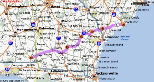
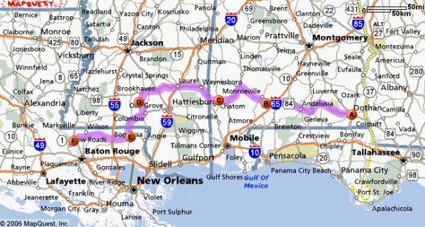
Charleston SC to St. Francisville LA (Cookies Bike Festival Idea) 866 miles. Starting with my feet in the Atlantic waters. I'd like to get within range of Itzbenz in Jackson MS.
St Francisville, LA to Las Vegas NM 1068 miles. The only reason I chose Las Vegas is I understand it is at the bottom of a Rocky Range.
Las Vegas NM to San Diego 933 miles, and I'm flexible on the Pacific landing zone, just as long as I get a picture of the bike on the beach.....My son can drive me to San Diego after the tires hit the waves.
That is PART A
I'd like to make it a shared adventure, drink beer in the sunset, figure out where the swimming holes are. St. Francisville with Col. Cookie, race those Spookytoothers, ride alongside as many forum folks as possible.
What I have in mind is creating an Appalachian Trail type journey, where benchmarks can be established, goodwill generated in small towns via pre-arranged newspaper articles. Places I can UPS supplies ahead of time, like the hikers do on the AT....
The whole point is somebody is GOING to do it one day, and I'd like to try it after the spring kidding season is over. If somebody else takes the forum knowledge & routing, precedes me or tries for a better time/distance challenge, that would be EXCELLENT.
With the forum assistance and input, it may be fun to share the whole enterprise from start to finish.
Last summer, when I did the Denver Round Trip it was with the crappiest AAA foldup maps. And it was without the benefit of THIS "greatest forum on the internet*" (quoting somebody else, but I concur).
I can't sit around and wait for a hurricane to get us together, so help me plan a tentative route, east to west, approximately 2867 miles, starting at a friends house in Charleston SC, ending at my son's house in San Diego.
I'd like to start with MAPS. The mileage, using Mapquest, have interstates involved, so my mileage number 2867 is bogus anyway.
I've divided it into 3 chunks.
Charleston SC to St. Francisville LA (Cookies Bike Festival Idea) 866 miles. Starting with my feet in the Atlantic waters. I'd like to get within range of Itzbenz in Jackson MS.
St Francisville, LA to Las Vegas NM 1068 miles. The only reason I chose Las Vegas is I understand it is at the bottom of a Rocky Range.
Las Vegas NM to San Diego 933 miles, and I'm flexible on the Pacific landing zone, just as long as I get a picture of the bike on the beach.....My son can drive me to San Diego after the tires hit the waves.
That is PART A
I'd like to make it a shared adventure, drink beer in the sunset, figure out where the swimming holes are. St. Francisville with Col. Cookie, race those Spookytoothers, ride alongside as many forum folks as possible.
What I have in mind is creating an Appalachian Trail type journey, where benchmarks can be established, goodwill generated in small towns via pre-arranged newspaper articles. Places I can UPS supplies ahead of time, like the hikers do on the AT....
The whole point is somebody is GOING to do it one day, and I'd like to try it after the spring kidding season is over. If somebody else takes the forum knowledge & routing, precedes me or tries for a better time/distance challenge, that would be EXCELLENT.
With the forum assistance and input, it may be fun to share the whole enterprise from start to finish.